
Course
 The course for the 2016 Bull Run Run 50 Miler will be the same as was used in the last eight years. It will use all but .3 mile of the Bull Run Trail as well as the White Loop and the infamous Do Loop. This page has information about the course. You don't need to memorize anything here. The course will be well marked. But you may find it helpful to have an idea of where you are on the course at any given time.
Where is the Elevation Chart? What is the trail like?
These are, by far, the most common questions we get. Here are the answers.
Elevation change: The course has a lot of little ups and downs. None of these is greater than a 200 feet elevation change and most are about 150 feet. An elevation profile map would be a straight line with a lot of very little bumps and wouldn't help understand the course. We don't have an elevation profile.

Click for larger
Some of the hills on the course are gentle, a few are rather steep. None is long. The start is at about 310 feet above sea level and no other place on the course is higher. At its lowest, the course is about 110 feet above sea level. The only long, flat section of the course is the upstream end where there are two, flat miles (that you go out and back on).
Like most rivers, the Bull Run and Occoquan have carved a valley. The trail generally follows the course of the river. Sometimes the trail is on the edge of the river, sometimes on the nearby bank or cliff. Going up and down from the river's edge to the bank causes much of the elevation change.
We count about 20 climbs of ~150 feet. There are another four or five ~50 foot climbs. The net elevation change is zero since the start and finish are at the same place.

The rockiest part of the course is short. It's the trail under the bridge at the Marina. This way avoids the only significant traffic on the course and having to step over a guardrail.
Trail surface: This is a single track, dirt trail. Other than a few short (~200 yard) rocky sections, most of the course is runable. (The rocky sections are runable if you are good.) There can be rocks, roots, mud, and fallen trees anywhere. There are several stream crossings. Most of the big ones now have bridges. (Those bridges, however, can be slippery and unstable.) In dry weather you can usually keep your feet dry. If it has rained before or during the event, you will not be able to keep your feet dry.
If you still have a question about the trail, feel free to contact the race director.
Distance: The Bull Run Run course was measured before your GPS was invented. We do not warrant that your GPS will agree with the distances we list. We believe that our course is about 50 miles long. That is all current management of the event cares about.
The Course
The course is a double out and back with a loop on the end of the second out and back.
You start at Hemlock Overlook. After taking a three quarter mile loop around the parking lot to get spread out, you run down to the river and turn right, going upstream. You cross Popes Head Creek and run to the first aid station at Centreville Road. After this aid station, you keep going upstream to near the end of the trail in Bull Run Regional Park. You will cross the new, fancy bridge over Cub Run, go about 50 yards, turn right, and run through a sea of bluebells. After about a half mile, you will turn around at the point where the trail makes a 90 degree left turn away from Cub Run.
| BRR Milage Chart | ||
|---|---|---|
| Point | Sec | Cum |
| Start | 0 | 0 |
| Centreville Road | 7.2 | 7.2 |
| Turnaround | 2.2 | 9.4 |
| Centreville Road | 2.2 | 11.6 |
| Hemlock | 5 | 16.6 |
| Marina | 4.5 | 21.1 |
| Wolf Run Shoals | 5 | 26.1 |
| Fountainhead | 2 | 28.1 |
| Do Loop In | 4.4 | 32.5 |
| Do Loop Out | 3 | 35.5 |
| Fountainhead | 2.4 | 37.9 |
| Wolf Run Shoals | 2 | 39.9 |
| Marina | 5 | 44.9 |
| Finish | 5.5 | 50.4 |
| All points above are aid stations with the exception of the turnaround. | ||
See also: Cutoff Times | ||
After the turnaround, you go back to Centreville Road for a second shot at the aid station and then straight downstream to Hemlock Overlook for an aid station located at the start/finish area. You go up the hill to Hemlock from the upstream, Popes Head Creek side. You don't go up the hill the way you came down at the start. You will cross Popes Head Creek just before you head up the hill.
After partaking of the aid station at Hemlock, you go down the hill as you did at the start, but when you get to the stream, you turn left and head downstream. You go through the soccer fields and then to the Bull Run Marina for an aid station. After the Marina, you arrive at the famous aid station at Wolf Run Shoals. After Wolf Run Shoals, it is only two miles to the aid station at Fountainhead Regional Park. After this aid station, you do the White Loop, coming out by a chain link fence where you turn left and head out on a blue blazed horse trail.
You take the blue blazed horse trail to the next aid station which is at the entrance to the infamous Do Loop. The Do Loop is like a lollipop on a stick. You go out the stick, go around the lollipop, and come back on the stick. You do the loop counterclockwise. Be sure to turn right at the intersection and when you get back to the intersection, go straight—don't do the loop a second time (although if you do, you won't be the first).
After you survive the Do Loop, you go straight back to Fountainhead without doing the White Loop. Then you go to Wolf Run Shoals, the Marina, and then the finish. You go up the hill to the finish from the Popes Head Creek side. You will go up the same way you did when you came back to Hemlock after the first turnaround. The result is that you always go down the hill on one trail and always up the trail on another one.
Cutoff Times
| Bull Run Run Cutoff Times | ||
|---|---|---|
| Aid Station | Race Time | Clock Time |
| Fountainhead (first pass) | 7:15 | 1:45PM |
| Do Loop (first pass) | 8:20 | 2:50PM |
| Fountainhead (second pass) | 9:45 | 4:15PM |
| Bull Run Marina (second pass) | 11:30 | 6:00PM |
| Finish | 13:00* | 7:30 PM |
The race has a 13-hour time limit. There are four aid station locations that a runner must depart by specific times to continue in the race. These times are generously calculated to allow the runner time to meet the 13-hour overall time limit. There are no exceptions to these cutoffs. Any runner who continues after being asked to give up his or her race number will be banned from all future VHTRC events and bears all responsibility for his safety. (Note: if you miss the time limit going into the Do Loop, you must run, walk, or crawl straight back to Fountainhead. You can't actually quit running at this point unless you have serious medical problems.)
* Special note: You must finish within 13 hours, which means that the race clock must read 12:59:59 or faster when you cross the finish line to be an "official finisher." See the important note on official finishers.
Maps
At right is a GPS track of the course. You can view it enlarged in Google Maps. (If you zoom in on the track, GPS error will make it appear that the out and back routes are different. For the most part, they are not.)
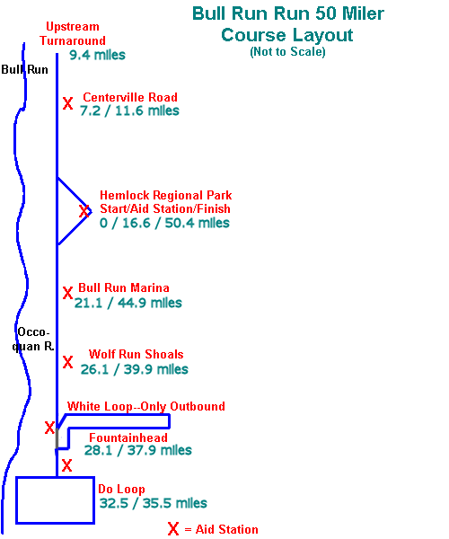
We still have our schematic outline of the course below. It will give you an understanding of the relative locations of the sections of the course and the aid stations.
The REI map of the Bull Run Trail is excellent to get you to the start and the aid stations by car, but it does not show the "Do Loop" or the "White Loop." That map shows a 19 mile trail that does not explain where the extra 12 miles are. You can also consult these maps on Alan Day's site.

A more common trail surface -- here in the bluebells at the upstream turnaround. See also this section.
Crews: The map below is not intended for you. It will probably confuse you. Check out the crew instructions.
If There is High Water: If the water in Bull Run is high, we may have to change the course. There is a high water course planned in case we need it.
The map below is not intended to portray the course precisely. It does show the relative relationship of the check points and aid stations. In conjunction with the REI map, it should give you a good idea of the course. A few points about the map:
- Since the stream goes diagonally across a real map, terms like "west" or "north" can be confusing. Think of the top of the map as "upstream" and the bottom as "downstream." (Technically, at the downstream end of the course, the stream is no longer the Bull Run. It's the Occoquan River.) The stream (the Bull Run that joins the Occoquan River) flows along the left of the map from the top to the bottom. The town of Manassass and Bull Run Regional Park are at the top of the map while Lorton and I-95 would be off the map at the bottom.
- To see how you run the course, click the "Tour the Course" button.
- This map does not show the loop through Hemlock Overlook at the beginning of the race. This short loop is designed to spread out the field before it hits the single track trail.
- Detailed maps and further information about the Bull Run Trail are on the PATC Site.
- If you want to load the map below all by itself in a page, click here. That may make it easier to print although it may not be worth printing.
- This map is Anstr's fault. Don't blame anyone else for it! Remember it's not to scale!
Back to: BRR Home Page | VHTRC Home Page | News Page